
Mount Kinbo
金峰山
Kumamoto, Kumamoto · Elevation 665 m
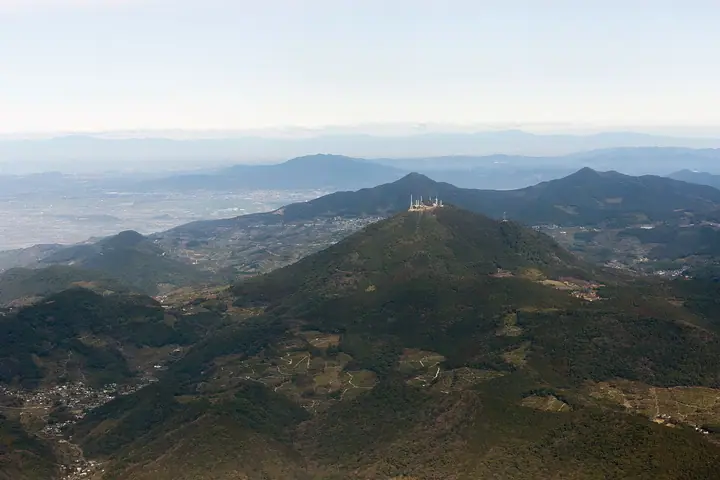
Kinpōzan is a 665 m caldera volcano on the western edge of Kumamoto City, with its central cone Ichinotake making the prominent skyline visible from almost anywhere in the city — locally paired with Aso to the east as "the Kinpōzan of the west." Kinpō Shrine sits on the summit, while the slopes hold Reigandō Cave, where Miyamoto Musashi is said to have written the Book of Five Rings, and the Tōge no Chaya tea house immortalised in Natsume Sōseki's novel Kusamakura. The 360° panorama from the top takes in the Ariake Sea, Mount Unzen, the Aso outer rim and the Amakusa islands.
Mount Kinbo at a glance
- Weather: The most settled day in the next 7 days is Sun, November 8: clear, gusts up to 3 m/s.
- Route: The shortest is Kumamoto Mount Kinbo Sarusuberi Circuit: about 1 h 4 min, 1.9 km, about 260 m of climbing.
Mount Kinbo weather (hourly, 14 days)
Sunrise today 06:36, sunset 17:26
| Tue, 11/3 | Wed, 11/4 | Thu, 11/5 | Fri, 11/6 | Sat, 11/7 | Sun, 11/8 | Mon, 11/9 | Tue, 11/10 | Wed, 11/11 | Thu, 11/12 | Fri, 11/13 | Sat, 11/14 | Sun, 11/15 | Mon, 11/16 | Tue, 11/17 | |||||||||||||||||||||||||||||||||||||||||||||||||||||||||||||||||||||||
|---|---|---|---|---|---|---|---|---|---|---|---|---|---|---|---|---|---|---|---|---|---|---|---|---|---|---|---|---|---|---|---|---|---|---|---|---|---|---|---|---|---|---|---|---|---|---|---|---|---|---|---|---|---|---|---|---|---|---|---|---|---|---|---|---|---|---|---|---|---|---|---|---|---|---|---|---|---|---|---|---|---|---|---|---|---|
| Japan time | 15 | 17 | 19 | 21 | 23 | 1 | 3 | 5 | 7 | 9 | 11 | 13 | 15 | 18 | 21 | 0 | 3 | 6 | 9 | 12 | 15 | 18 | 21 | 0 | 3 | 6 | 9 | 12 | 15 | 18 | 21 | 0 | 3 | 6 | 9 | 12 | 15 | 18 | 21 | 0 | 3 | 6 | 9 | 12 | 15 | 18 | 21 | 0 | 3 | 6 | 9 | 15 | 21 | 3 | 9 | 15 | 21 | 3 | 9 | 15 | 21 | 3 | 9 | 15 | 21 | 3 | 9 | 15 | 21 | 3 | 9 | 15 | 21 | 3 | 9 | 15 | 21 | 3 | 9 | 15 | 21 | 3 | 9 | 15 | |
  | |   | |   | | | |   | | | | |   |   | | |   | |   |   |   | | | | |  | | |  | | | | | | | | | | | | | | | | | | | | | | |   | | | | | | | | | | | |  | | | | | | | | | | | | | | |   | | | | | ||
| Temperature | °C | 16° | 14° | 13° | 12° | 11° | 10° | 10° | 10° | 10° | 12° | 16° | 18° | 18° | 15° | 14° | 13° | 13° | 12° | 14° | 17° | 17° | 16° | 16° | 15° | 13° | 12° | 14° | 17° | 15° | 11° | 8° | 7° | 6° | 5° | 8° | 11° | 12° | 8° | 6° | 4° | 2° | 2° | 7° | 12° | 13° | 11° | 10° | 9° | 9° | 9° | 10° | 15° | 9° | 5° | 8° | 13° | 7° | 3° | 9° | 12° | 6° | 2° | 7° | 13° | 7° | 3° | 8° | 16° | 8° | 5° | 8° | 17° | 10° | 11° | 14° | 16° | 12° | 13° | 14° | 17° | 10° | 7° | 10° | 16° |
| Precipitation | mm | 0.6 | 0.3 | 1.9 | 0.1 | 5 | 2.0 | 0.9 | 0.2 | 0.1 | 0.3 | 0.2 | 6 | 4.2 | 0.1 | 0.2 | |||||||||||||||||||||||||||||||||||||||||||||||||||||||||||||||||||||
| New snow | cm | ||||||||||||||||||||||||||||||||||||||||||||||||||||||||||||||||||||||||||||||||||||
| Snow depth | cm | 0 | 0 | 0 | 0 | 0 | 0 | 0 | 0 | 0 | 0 | 0 | 0 | 0 | 0 | 0 | 0 | 0 | 0 | 0 | 0 | 0 | 0 | 0 | 0 | 0 | 0 | 0 | 0 | 0 | 0 | 0 | 0 | 0 | 0 | 0 | 0 | 0 | 0 | 0 | 0 | 0 | 0 | 0 | 0 | 0 | 0 | 0 | 0 | 0 | 0 | 0 | 0 | 0 | 0 | 0 | 0 | 0 | 0 | 0 | 0 | 0 | 0 | 0 | 0 | 0 | 0 | 0 | 0 | 0 | 0 | 0 | 0 | 0 | 0 | 0 | 0 | 0 | 0 | 0 | 0 | 0 | 0 | 0 | 0 |
| Wind | m/s | 4 | 3 | 3 | 2 | 2 | 2 | 1 | 1 | 1 | 1 | 1 | 2 | 3 | 0 | 1 | 2 | 1 | 1 | 1 | 1 | 5 | 3 | 1 | 2 | 2 | 1 | 1 | 4 | 5 | 3 | 1 | 2 | 3 | 2 | 3 | 3 | 3 | 4 | 2 | 1 | 0 | 1 | 0 | 0 | 0 | 1 | 0 | 0 | 1 | 0 | 2 | 4 | 3 | 1 | 0 | 4 | 0 | 1 | 3 | 4 | 2 | 0 | 0 | 2 | 1 | 1 | 1 | 3 | 1 | 1 | 1 | 1 | 1 | 1 | 1 | 2 | 2 | 2 | 2 | 4 | 2 | 1 | 1 | 4 |
| Wind gusts | m/s | 10 | 9 | 7 | 6 | 6 | 5 | 5 | 3 | 3 | 3 | 5 | 5 | 7 | 7 | 3 | 3 | 4 | 2 | 4 | 5 | 12 | 12 | 8 | 7 | 6 | 5 | 5 | 9 | 11 | 11 | 7 | 5 | 8 | 7 | 8 | 9 | 9 | 9 | 8 | 5 | 2 | 2 | 3 | 3 | 3 | 3 | 3 | 2 | 3 | 3 | 5 | 10 | 9 | 7 | 4 | 10 | 11 | 4 | 7 | 9 | 9 | 4 | 3 | 5 | 5 | 4 | 4 | 7 | 7 | 3 | 3 | 4 | 4 | 4 | 4 | 7 | 5 | 5 | 7 | 10 | 10 | 5 | 4 | 9 |
| Wind dir. | ↓ | ↓ | ↓ | ↓ | ↓ | ↓ | ↓ | ↓ | ↓ | ↓ | ↓ | ↓ | ↓ | ↓ | ↓ | ↓ | ↓ | ↓ | ↓ | ↓ | ↓ | ↓ | ↓ | ↓ | ↓ | ↓ | ↓ | ↓ | ↓ | ↓ | ↓ | ↓ | ↓ | ↓ | ↓ | ↓ | ↓ | ↓ | ↓ | ↓ | ↓ | ↓ | ↓ | ↓ | ↓ | ↓ | ↓ | ↓ | ↓ | ↓ | ↓ | ↓ | ↓ | ↓ | ↓ | ↓ | ↓ | ↓ | ↓ | ↓ | ↓ | ↓ | ↓ | ↓ | ↓ | ↓ | ↓ | ↓ | ↓ | ↓ | ↓ | ↓ | ↓ | ↓ | ↓ | ↓ | ↓ | ↓ | ↓ | ↓ | ↓ | ↓ | ↓ | ↓ | |
Mount Kinbo hiking routes
Hiking times are estimates calculated from the terrain.
Lists that include Mount Kinbo
Kumamoto 100 Famous Mountains · Elevations of 1003 Mountains of Japan · 1000 Mountains of Japan
Mount Kinbo facts
- Also known as
- Mount Kinpo
- Elevation
- 665 m
- Location
- Kumamoto, Kumamoto
32.813878, 130.638873 - Website
- www.city.kumamoto.jp
- Wikipedia
- ja.wikipedia.org