
Mount Fuku
福山
Sōja-shi, Okayama · Elevation 302 m
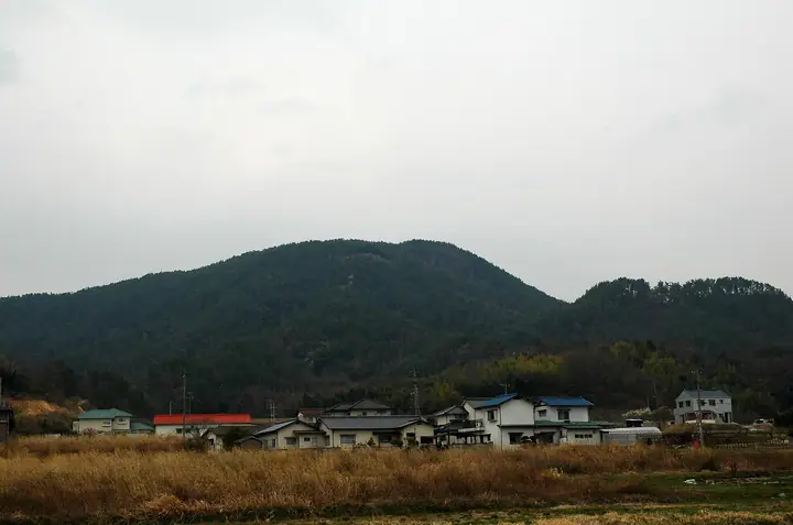
Mount Fuku (302 m) straddles the Yamate and Kiyone districts of Soja City, Okayama Prefecture; its summit holds the nationally designated Fukuyama Castle ruins, scene of the 14th-century Fukuyama Battle recorded in the Taiheiki. The subsidiary Sachiyama Castle on the mid-slope is linked to the main keep by a ridge path nicknamed the "Path of Happiness." Several routes—including a 1,234-step staircase, a paraglider-launch slope on the western face, and combined loop options—climb a peak that overlooks the Soja Plain and the Kibiji ancient sites.
Mount Fuku at a glance
- Weather: The most settled day in the next 7 days is Wed, November 4: cloudy, gusts up to 5 m/s.
- Route: The shortest is Fukuyama Castle Ruins Return from the History Plaza Trailhead: about 1 h 22 min, 2.1 km, about 280 m of climbing.
Mount Fuku weather (hourly, 14 days)
Sunrise today 06:27, sunset 17:10
| Tue, 11/3 | Wed, 11/4 | Thu, 11/5 | Fri, 11/6 | Sat, 11/7 | Sun, 11/8 | Mon, 11/9 | Tue, 11/10 | Wed, 11/11 | Thu, 11/12 | Fri, 11/13 | Sat, 11/14 | Sun, 11/15 | Mon, 11/16 | Tue, 11/17 | |||||||||||||||||||||||||||||||||||||||||||||||||||||||||||||||||||||||
|---|---|---|---|---|---|---|---|---|---|---|---|---|---|---|---|---|---|---|---|---|---|---|---|---|---|---|---|---|---|---|---|---|---|---|---|---|---|---|---|---|---|---|---|---|---|---|---|---|---|---|---|---|---|---|---|---|---|---|---|---|---|---|---|---|---|---|---|---|---|---|---|---|---|---|---|---|---|---|---|---|---|---|---|---|---|
| Japan time | 21 | 23 | 1 | 3 | 5 | 7 | 9 | 11 | 13 | 15 | 17 | 19 | 21 | 0 | 3 | 6 | 9 | 12 | 15 | 18 | 21 | 0 | 3 | 6 | 9 | 12 | 15 | 18 | 21 | 0 | 3 | 6 | 9 | 12 | 15 | 18 | 21 | 0 | 3 | 6 | 9 | 12 | 15 | 18 | 21 | 0 | 3 | 6 | 9 | 12 | 15 | 21 | 3 | 9 | 15 | 21 | 3 | 9 | 15 | 21 | 3 | 9 | 15 | 21 | 3 | 9 | 15 | 21 | 3 | 9 | 15 | 21 | 3 | 9 | 15 | 21 | 3 | 9 | 15 | 21 | 3 | 9 | 15 | 21 | |
  | | |   | |   | |   | | | | |   |   | | |   | | |   |   | | |  |  | | | | | | | | | | | | | | | | |   | | | | | | | | | | |   | | | | | | | |  | | | | | | | | | | | | | | | | | |   | |  | | | | ||
| Temperature | °C | 11° | 10° | 9° | 9° | 9° | 8° | 13° | 14° | 15° | 15° | 13° | 13° | 13° | 12° | 11° | 11° | 13° | 18° | 17° | 15° | 14° | 14° | 12° | 12° | 16° | 19° | 17° | 12° | 9° | 6° | 6° | 5° | 11° | 14° | 13° | 8° | 6° | 4° | 4° | 4° | 9° | 12° | 13° | 9° | 9° | 9° | 8° | 8° | 12° | 16° | 16° | 8° | 5° | 11° | 16° | 7° | 7° | 9° | 12° | 6° | 3° | 10° | 14° | 7° | 6° | 12° | 13° | 5° | 2° | 10° | 14° | 8° | 8° | 13° | 14° | 13° | 11° | 16° | 17° | 10° | 5° | 9° | 14° | 6° |
| Precipitation | mm | 0.2 | 0.2 | 0.6 | 1.2 | 0.5 | 0.3 | 0.2 | 0.1 | 1.1 | 5 | 1.2 | 0.2 | ||||||||||||||||||||||||||||||||||||||||||||||||||||||||||||||||||||||||
| New snow | cm | ||||||||||||||||||||||||||||||||||||||||||||||||||||||||||||||||||||||||||||||||||||
| Snow depth | cm | 0 | 0 | 0 | 0 | 0 | 0 | 0 | 0 | 0 | 0 | 0 | 0 | 0 | 0 | 0 | 0 | 0 | 0 | 0 | 0 | 0 | 0 | 0 | 0 | 0 | 0 | 0 | 0 | 0 | 0 | 0 | 0 | 0 | 0 | 0 | 0 | 0 | 0 | 0 | 0 | 0 | 0 | 0 | 0 | 0 | 0 | 0 | 0 | 0 | 0 | 0 | 0 | 0 | 0 | 0 | 0 | 0 | 0 | 0 | 0 | 0 | 0 | 0 | 0 | 0 | 0 | 0 | 0 | 0 | 0 | 0 | 0 | 0 | 0 | 0 | 0 | 0 | 0 | 0 | 0 | 0 | 0 | 0 | 0 |
| Wind | m/s | 2 | 2 | 1 | 2 | 2 | 1 | 1 | 1 | 1 | 2 | 1 | 1 | 1 | 1 | 1 | 2 | 1 | 1 | 2 | 1 | 1 | 2 | 3 | 3 | 3 | 5 | 5 | 4 | 2 | 2 | 2 | 2 | 3 | 4 | 4 | 2 | 2 | 1 | 1 | 1 | 1 | 2 | 2 | 2 | 1 | 1 | 1 | 1 | 1 | 3 | 3 | 1 | 1 | 3 | 4 | 2 | 3 | 1 | 4 | 2 | 1 | 1 | 4 | 2 | 2 | 4 | 4 | 1 | 1 | 1 | 2 | 1 | 2 | 3 | 2 | 1 | 2 | 3 | 4 | 3 | 1 | 1 | 1 | 1 |
| Wind gusts | m/s | 6 | 4 | 3 | 3 | 3 | 3 | 4 | 5 | 4 | 4 | 4 | 2 | 3 | 3 | 3 | 3 | 3 | 4 | 4 | 3 | 2 | 4 | 7 | 6 | 9 | 11 | 11 | 11 | 7 | 4 | 3 | 3 | 7 | 10 | 10 | 8 | 4 | 3 | 3 | 2 | 3 | 6 | 6 | 5 | 5 | 2 | 3 | 3 | 4 | 6 | 8 | 5 | 3 | 6 | 9 | 9 | 7 | 6 | 9 | 8 | 3 | 3 | 9 | 9 | 4 | 8 | 10 | 9 | 3 | 4 | 6 | 5 | 4 | 6 | 6 | 4 | 5 | 7 | 10 | 11 | 7 | 4 | 6 | 4 |
| Wind dir. | ↓ | ↓ | ↓ | ↓ | ↓ | ↓ | ↓ | ↓ | ↓ | ↓ | ↓ | ↓ | ↓ | ↓ | ↓ | ↓ | ↓ | ↓ | ↓ | ↓ | ↓ | ↓ | ↓ | ↓ | ↓ | ↓ | ↓ | ↓ | ↓ | ↓ | ↓ | ↓ | ↓ | ↓ | ↓ | ↓ | ↓ | ↓ | ↓ | ↓ | ↓ | ↓ | ↓ | ↓ | ↓ | ↓ | ↓ | ↓ | ↓ | ↓ | ↓ | ↓ | ↓ | ↓ | ↓ | ↓ | ↓ | ↓ | ↓ | ↓ | ↓ | ↓ | ↓ | ↓ | ↓ | ↓ | ↓ | ↓ | ↓ | ↓ | ↓ | ↓ | ↓ | ↓ | ↓ | ↓ | ↓ | ↓ | ↓ | ↓ | ↓ | ↓ | ↓ | ↓ | |
Mount Fuku hiking routes
- Fukuyama Castle Ruins Return from the History Plaza Trailhead 2.1 km · Ascent 280 m parking
- Kurashiki Loop from Anyoji in Asahara to the Fukuyama Castle Ruins 5.0 km · Ascent 335 m 安養寺駐車場
Hiking times are estimates calculated from the terrain.
Huts, campsites and lodging near Mount Fuku
Lodging
- 国民宿舎 サンロード吉備路
- 大黒家旅館
- Hotel Ikedaya
- ホテル&ウィークリー フレンド倉敷
- ベッセルホテル倉敷
Lists that include Mount Fuku
Mount Fuku facts
- Elevation
- 302 m
- Location
- Sōja-shi, Okayama
34.646457, 133.759564 - Website
- www.city.soja.okayama.jp
- Trail Map
- www.city.soja.okayama.jp (PDF)
- Access Information
- www.city.soja.okayama.jp
- Wikipedia
- ja.wikipedia.org