
Hoyoshidake
甫与志岳
Kimotsuki, Kagoshima · Elevation 967 m
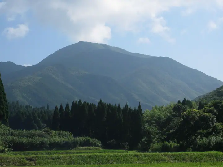
A 967-meter peak in Kimotsuki Town (Kimotsuki District), south-eastern Ōsumi Peninsula of Kagoshima Prefecture, and the highest summit of the Kimotsuki Range. Together with Kuroson-dake and Kunimi-yama to the north, it forms the "Three Peaks of Kunimi." The summit is a giant granite outcrop 20 m tall and 120 m round, with a stone shrine in a recess dedicated to Hikohohodemi-no-Mikoto and a first-order triangulation point on top; the panorama sweeps from the Pacific to the Takakuma and Kirishima ranges, with the Satsuma Peninsula, Yakushima and Tanegashima beyond Kagoshima Bay. The slopes are noted for the Kimotsuki-mitsuba and Tsukushi-akebono azaleas endemic to the range. Kimotsuki Tourism Association maintains the Himekado-to-Futamata route via the summit (about 80 minutes from Himekado trailhead). Listed in the Kyūshū 100 Mountains.
Hoyoshidake at a glance
- Weather: The most settled day in the next 7 days is Sat, November 7: clear, gusts up to 6 m/s.
Hoyoshidake weather (hourly, 14 days)
Sunrise today 06:33, sunset 17:27
| Tue, 11/3 | Wed, 11/4 | Thu, 11/5 | Fri, 11/6 | Sat, 11/7 | Sun, 11/8 | Mon, 11/9 | Tue, 11/10 | Wed, 11/11 | Thu, 11/12 | Fri, 11/13 | Sat, 11/14 | Sun, 11/15 | Mon, 11/16 | Tue, 11/17 | |||||||||||||||||||||||||||||||||||||||||||||||||||||||||||||||||||||||
|---|---|---|---|---|---|---|---|---|---|---|---|---|---|---|---|---|---|---|---|---|---|---|---|---|---|---|---|---|---|---|---|---|---|---|---|---|---|---|---|---|---|---|---|---|---|---|---|---|---|---|---|---|---|---|---|---|---|---|---|---|---|---|---|---|---|---|---|---|---|---|---|---|---|---|---|---|---|---|---|---|---|---|---|---|---|
| Japan time | 15 | 17 | 19 | 21 | 23 | 1 | 3 | 5 | 7 | 9 | 11 | 13 | 15 | 18 | 21 | 0 | 3 | 6 | 9 | 12 | 15 | 18 | 21 | 0 | 3 | 6 | 9 | 12 | 15 | 18 | 21 | 0 | 3 | 6 | 9 | 12 | 15 | 18 | 21 | 0 | 3 | 6 | 9 | 12 | 15 | 18 | 21 | 0 | 3 | 6 | 9 | 15 | 21 | 3 | 9 | 15 | 21 | 3 | 9 | 15 | 21 | 3 | 9 | 15 | 21 | 3 | 9 | 15 | 21 | 3 | 9 | 15 | 21 | 3 | 9 | 15 | 21 | 3 | 9 | 15 | 21 | 3 | 9 | 15 | |
  |   |   |   | | | | | | | |   |   |   | | | |   | |   | |   | | | | |  | | | | |  | | | | | | | | | | | | | | | | | | | | | |   | | |   | | | | | | | | | | | | | | | | | | | | | | | |  | | |   | ||
| Temperature | °C | 16° | 14° | 12° | 11° | 10° | 10° | 10° | 9° | 10° | 14° | 17° | 17° | 16° | 14° | 13° | 12° | 11° | 12° | 15° | 20° | 18° | 15° | 15° | 14° | 13° | 11° | 14° | 17° | 16° | 12° | 9° | 6° | 4° | 3° | 8° | 12° | 13° | 7° | 5° | 5° | 3° | 4° | 10° | 14° | 13° | 11° | 9° | 8° | 7° | 7° | 12° | 14° | 9° | 8° | 9° | 13° | 5° | 2° | 8° | 12° | 4° | 2° | 9° | 13° | 5° | 3° | 9° | 14° | 7° | 6° | 11° | 14° | 10° | 11° | 13° | 14° | 14° | 12° | 13° | 17° | 9° | 10° | 12° | 15° |
| Precipitation | mm | 0.2 | 0.4 | 0.6 | 0.7 | 0.1 | 0.2 | 0.3 | 0.2 | 0.3 | 0.2 | 1.0 | 0.3 | 0.3 | 2.4 | 2.7 | 12 | 18 | 1.0 | 0.2 | 1.9 | ||||||||||||||||||||||||||||||||||||||||||||||||||||||||||||||||
| New snow | cm | ||||||||||||||||||||||||||||||||||||||||||||||||||||||||||||||||||||||||||||||||||||
| Snow depth | cm | 0 | 0 | 0 | 0 | 0 | 0 | 0 | 0 | 0 | 0 | 0 | 0 | 0 | 0 | 0 | 0 | 0 | 0 | 0 | 0 | 0 | 0 | 0 | 0 | 0 | 0 | 0 | 0 | 0 | 0 | 0 | 0 | 0 | 0 | 0 | 0 | 0 | 0 | 0 | 0 | 0 | 0 | 0 | 0 | 0 | 0 | 0 | 0 | 0 | 0 | 0 | 0 | 0 | 0 | 0 | 0 | 0 | 0 | 0 | 0 | 0 | 0 | 0 | 0 | 0 | 0 | 0 | 0 | 0 | 0 | 0 | 0 | 0 | 0 | 0 | 0 | 0 | 0 | 0 | 0 | 0 | 0 | 0 | 0 |
| Wind | m/s | 1 | 1 | 2 | 2 | 2 | 2 | 2 | 2 | 3 | 3 | 5 | 5 | 5 | 3 | 2 | 1 | 1 | 2 | 1 | 1 | 3 | 3 | 3 | 3 | 3 | 2 | 3 | 4 | 4 | 3 | 3 | 2 | 2 | 2 | 2 | 1 | 1 | 1 | 0 | 1 | 2 | 2 | 2 | 3 | 2 | 2 | 1 | 1 | 1 | 0 | 0 | 1 | 1 | 2 | 2 | 4 | 1 | 0 | 1 | 2 | 0 | 1 | 0 | 1 | 1 | 0 | 1 | 2 | 1 | 1 | 2 | 3 | 2 | 1 | 2 | 2 | 2 | 2 | 2 | 3 | 0 | 2 | 2 | 0 |
| Wind gusts | m/s | 7 | 6 | 5 | 6 | 6 | 6 | 7 | 8 | 9 | 11 | 14 | 14 | 14 | 13 | 9 | 7 | 5 | 6 | 5 | 6 | 10 | 11 | 8 | 10 | 10 | 8 | 9 | 10 | 12 | 11 | 10 | 8 | 6 | 6 | 6 | 6 | 6 | 4 | 3 | 5 | 6 | 8 | 8 | 9 | 8 | 6 | 5 | 4 | 3 | 3 | 3 | 6 | 5 | 5 | 7 | 10 | 10 | 4 | 4 | 6 | 6 | 3 | 3 | 5 | 4 | 2 | 5 | 7 | 5 | 6 | 7 | 10 | 9 | 8 | 9 | 10 | 9 | 9 | 8 | 11 | 8 | 5 | 6 | 7 |
| Wind dir. | ↓ | ↓ | ↓ | ↓ | ↓ | ↓ | ↓ | ↓ | ↓ | ↓ | ↓ | ↓ | ↓ | ↓ | ↓ | ↓ | ↓ | ↓ | ↓ | ↓ | ↓ | ↓ | ↓ | ↓ | ↓ | ↓ | ↓ | ↓ | ↓ | ↓ | ↓ | ↓ | ↓ | ↓ | ↓ | ↓ | ↓ | ↓ | ↓ | ↓ | ↓ | ↓ | ↓ | ↓ | ↓ | ↓ | ↓ | ↓ | ↓ | ↓ | ↓ | ↓ | ↓ | ↓ | ↓ | ↓ | ↓ | ↓ | ↓ | ↓ | ↓ | ↓ | ↓ | ↓ | ↓ | ↓ | ↓ | ↓ | ↓ | ↓ | ↓ | ↓ | ↓ | ↓ | ↓ | ↓ | ↓ | ↓ | ↓ | ↓ | ↓ | ↓ | ↓ | ↓ | |
Lists that include Hoyoshidake
Kyushu 100 Famous Mountains · Elevations of 1003 Mountains of Japan · 1000 Mountains of Japan
Hoyoshidake facts
- Elevation
- 967 m
- Location
- Kimotsuki, Kagoshima
31.264140, 130.990108 - Website
- kankou-kimotsuki.net
- Trail Map
- kankou-kimotsuki.net (PDF)
- Wikipedia
- ja.wikipedia.org