
Mount Ikeguchi
池口岳
คาวาเนฮง, ชิซูโอกะ / อีดะ, นากาโนะ · ความสูง 2,392 ม.
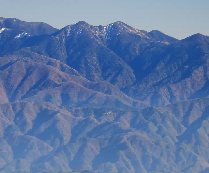
Mount Ikeguchi is a 2,392 m twin-peaked mountain (north summit) on the border between Iida City in Nagano and Shizuoka City in Shizuoka, rising in the deep-southern Akaishi Range — "Shin-nanbu" of the South Japanese Alps. The north summit and the 2,375.6 m south summit form a distinctive twin profile, and the area from Ikeguchi-dake to Mount Tekkari is designated as the Wilderness Area of Minami-Alps National Park. Listed in the Nihon Nihyaku Meizan, the Shinshū Hyakumeizan, and the Shizuoka no Hyakuzan, the mountain is prized for its moss-cloaked subalpine conifer forest and the open Shika-no-Taira meadow, which commands sweeping views of Mounts Hijiri and Tekkari. The sole approach is the long round trip from the Ikeguchi village trailhead in Minami-Shinano, Iida City, climbing via Kuro-nagi to the junction and on to the north peak — about eleven hours total — and is a designated registered trail under Nagano's mountaineering safety ordinance, requiring a filed climbing plan.
สรุป Mount Ikeguchi
- อากาศ: วันที่อากาศคงที่ที่สุดใน 7 วันข้างหน้าคือ อาทิตย์ 8 พฤศจิกายน: ท้องฟ้าแจ่มใส ลมกระโชกสูงสุด 8 ม./วินาที ศุกร์ 6 พ.ย., เสาร์ 7 พ.ย. ลมแรง (ลมกระโชกสูงสุด 16 ม./วินาที)
อากาศ Mount Ikeguchi (รายชั่วโมง 2 สัปดาห์)
วันนี้พระอาทิตย์ขึ้น 06:10 ตก 16:53
| อังคาร 3/11 | พุธ 4/11 | พฤหัส 5/11 | ศุกร์ 6/11 | เสาร์ 7/11 | อาทิตย์ 8/11 | จันทร์ 9/11 | อังคาร 10/11 | พุธ 11/11 | พฤหัส 12/11 | ศุกร์ 13/11 | เสาร์ 14/11 | อาทิตย์ 15/11 | จันทร์ 16/11 | อังคาร 17/11 | |||||||||||||||||||||||||||||||||||||||||||||||||||||||||||||||||||||||
|---|---|---|---|---|---|---|---|---|---|---|---|---|---|---|---|---|---|---|---|---|---|---|---|---|---|---|---|---|---|---|---|---|---|---|---|---|---|---|---|---|---|---|---|---|---|---|---|---|---|---|---|---|---|---|---|---|---|---|---|---|---|---|---|---|---|---|---|---|---|---|---|---|---|---|---|---|---|---|---|---|---|---|---|---|---|
| เวลาญี่ปุ่น | 21 | 23 | 1 | 3 | 5 | 7 | 9 | 11 | 13 | 15 | 17 | 19 | 21 | 0 | 3 | 6 | 9 | 12 | 15 | 18 | 21 | 0 | 3 | 6 | 9 | 12 | 15 | 18 | 21 | 0 | 3 | 6 | 9 | 12 | 15 | 18 | 21 | 0 | 3 | 6 | 9 | 12 | 15 | 18 | 21 | 0 | 3 | 6 | 9 | 12 | 15 | 21 | 3 | 9 | 15 | 21 | 3 | 9 | 15 | 21 | 3 | 9 | 15 | 21 | 3 | 9 | 15 | 21 | 3 | 9 | 15 | 21 | 3 | 9 | 15 | 21 | 3 | 9 | 15 | 21 | 3 | 9 | 15 | 21 | |
 |   | | | |   | |   | |   |   | | | | | |   | | |   | | | |   |  | | | |  | | | | | | | | | | | | |   | |   | | | | | | | | |   | | | |   | | |   |  | |   | | | | | | | | | | | | | | | | | | | | | | ||
| อุณหภูมิ | °C | -2° | -3° | -3° | -2° | -2° | 0° | 5° | 6° | 5° | 5° | 3° | 3° | 2° | 2° | 3° | 4° | 7° | 10° | 8° | 6° | 4° | 3° | 4° | 3° | 5° | 7° | 5° | 0° | -2° | -3° | -4° | -6° | 0° | 1° | 0° | -6° | -8° | -7° | -6° | -5° | 2° | 4° | 4° | -1° | -1° | 1° | 1° | 1° | 1° | 6° | 4° | -4° | -5° | 1° | 1° | -3° | -6° | -2° | 2° | -7° | -6° | -1° | 1° | -6° | -6° | 1° | 3° | -5° | -5° | 1° | 2° | -5° | -3° | 3° | 3° | 3° | 3° | 6° | 6° | -2° | -1° | 0° | 1° | -1° |
| ฝนและหิมะ | mm | 0.4 | 0.2 | 0.6 | 1.0 | 8 | 9 | 3.4 | 0.1 | 0.1 | 1.7 | 0.6 | 0.3 | 0.5 | 0.1 | 0.5 | 0.2 | 0.3 | 0.4 | 0.8 | 20 | 25 | 1.9 | 1.1 | 0.2 | 0.7 | |||||||||||||||||||||||||||||||||||||||||||||||||||||||||||
| หิมะตก | cm | 0.1 | |||||||||||||||||||||||||||||||||||||||||||||||||||||||||||||||||||||||||||||||||||
| หิมะสะสม | cm | 0 | 0 | 0 | 0 | 0 | 0 | 0 | 0 | 0 | 0 | 0 | 0 | 0 | 0 | 0 | 0 | 0 | 0 | 0 | 0 | 0 | 0 | 0 | 0 | 0 | 0 | 0 | 0 | 0 | 0 | 0 | 0 | 0 | 0 | 0 | 0 | 0 | 0 | 0 | 0 | 0 | 0 | 0 | 0 | 0 | 0 | 0 | 0 | 0 | 0 | 0 | 0 | 0 | 0 | 0 | 0 | 0 | 0 | 0 | 0 | 0 | 0 | 0 | 0 | 0 | 0 | 0 | 0 | 0 | 0 | 0 | 0 | 0 | 0 | 0 | 0 | 0 | 0 | 0 | 0 | 0 | 0 | 0 | 0 |
| ลม | m/s | 1 | 0 | 0 | 0 | 0 | 0 | 1 | 1 | 1 | 1 | 1 | 2 | 2 | 2 | 0 | 1 | 1 | 2 | 0 | 0 | 0 | 1 | 3 | 2 | 2 | 4 | 4 | 3 | 2 | 2 | 2 | 2 | 3 | 4 | 2 | 2 | 1 | 1 | 0 | 0 | 1 | 2 | 2 | 1 | 0 | 1 | 1 | 1 | 1 | 2 | 3 | 0 | 1 | 2 | 3 | 2 | 5 | 4 | 2 | 1 | 0 | 2 | 2 | 0 | 1 | 2 | 2 | 0 | 0 | 1 | 2 | 0 | 0 | 1 | 1 | 0 | 0 | 3 | 3 | 1 | 1 | 1 | 2 | 0 |
| ลมกระโชก | m/s | 4 | 4 | 4 | 4 | 4 | 4 | 5 | 6 | 6 | 6 | 7 | 9 | 11 | 15 | 14 | 9 | 6 | 8 | 8 | 6 | 7 | 10 | 16 | 16 | 11 | 16 | 16 | 15 | 12 | 11 | 12 | 13 | 14 | 15 | 15 | 11 | 9 | 7 | 6 | 6 | 6 | 8 | 8 | 9 | 7 | 8 | 8 | 7 | 7 | 10 | 12 | 9 | 5 | 8 | 13 | 10 | 22 | 22 | 18 | 10 | 4 | 7 | 9 | 7 | 8 | 11 | 11 | 7 | 4 | 5 | 8 | 7 | 5 | 8 | 11 | 13 | 13 | 12 | 16 | 12 | 5 | 4 | 8 | 8 |
| ทิศทางลม | ↓ | ↓ | ↓ | ↓ | ↓ | ↓ | ↓ | ↓ | ↓ | ↓ | ↓ | ↓ | ↓ | ↓ | ↓ | ↓ | ↓ | ↓ | ↓ | ↓ | ↓ | ↓ | ↓ | ↓ | ↓ | ↓ | ↓ | ↓ | ↓ | ↓ | ↓ | ↓ | ↓ | ↓ | ↓ | ↓ | ↓ | ↓ | ↓ | ↓ | ↓ | ↓ | ↓ | ↓ | ↓ | ↓ | ↓ | ↓ | ↓ | ↓ | ↓ | ↓ | ↓ | ↓ | ↓ | ↓ | ↓ | ↓ | ↓ | ↓ | ↓ | ↓ | ↓ | ↓ | ↓ | ↓ | ↓ | ↓ | ↓ | ↓ | ↓ | ↓ | ↓ | ↓ | ↓ | ↓ | ↓ | ↓ | ↓ | ↓ | ↓ | ↓ | ↓ | ↓ | |
กระท่อม ที่ตั้งแคมป์ และที่พักใกล้ Mount Ikeguchi
กระท่อมบนภูเขา
รายชื่อที่มี Mount Ikeguchi
200 ภูเขาที่มีชื่อเสียงของญี่ปุ่น · 300 ภูเขาที่มีชื่อเสียงของญี่ปุ่น · 100 ภูเขาที่มีชื่อเสียงของชินชู · 100 ภูเขาแห่งชิซูโอกะ · บัตรภูเขาชินชู · ระดับความสูงของภูเขา 1003 แห่งในญี่ปุ่น
ข้อมูลพื้นฐาน Mount Ikeguchi
- ชื่ออื่น
- 池口岳北峰
- ความสูง
- 2,392 ม.
- ที่ตั้ง
- คาวาเนฮง, ชิซูโอกะ / อีดะ, นากาโนะ
35.330256, 138.038363 - อุทยานแห่งชาติ
- 南アルプス国立公園
- เว็บไซต์
- blog.nagano-ken.jp
- วิกิพีเดีย
- ja.wikipedia.org