
Mt. Goharetsuyama
御破裂山
ซากูราอิ, นาระ · ความสูง 608 ม.
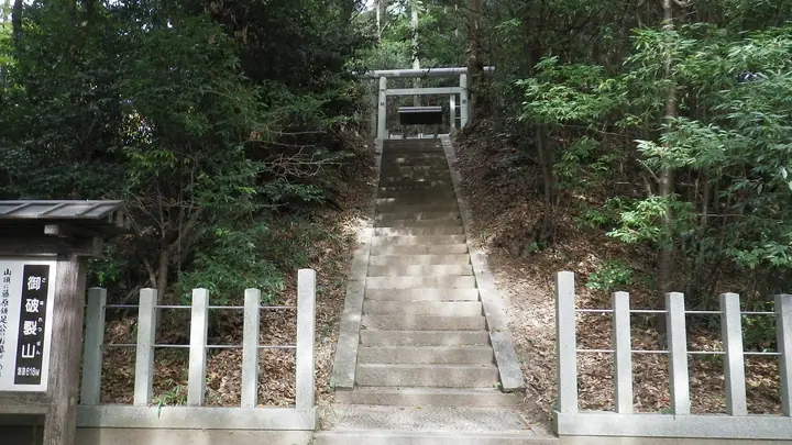
Mt. Goharetsuyama is a 607.7-meter peak in Tonomine, Sakurai City, Nara Prefecture, rising directly behind Tanzan Shrine. The summit holds the Tonomine tomb of Fujiwara no Kamatari, the seventh-century statesman who led the Taika Reform. According to long-standing tradition the mountain rumbles and the deity's image cracks before great calamities befall the nation — 37 such tremors are said to have been recorded — and this lore gives the peak its name ("the rumbling-bursting mountain"). A pilgrim path from the Tanzan Shrine precinct climbs the ridge to the tomb and summit lookout, which commands views of the Yamato Basin out to Osaka Bay on clear days.
สรุป Mt. Goharetsuyama
- อากาศ: วันที่อากาศคงที่ที่สุดใน 7 วันข้างหน้าคือ พฤหัส 5 พฤศจิกายน: มีเมฆมาก ลมกระโชกสูงสุด 5 ม./วินาที
อากาศ Mt. Goharetsuyama (รายชั่วโมง 2 สัปดาห์)
วันนี้พระอาทิตย์ขึ้น 06:19 ตก 17:02
| อังคาร 3/11 | พุธ 4/11 | พฤหัส 5/11 | ศุกร์ 6/11 | เสาร์ 7/11 | อาทิตย์ 8/11 | จันทร์ 9/11 | อังคาร 10/11 | พุธ 11/11 | พฤหัส 12/11 | ศุกร์ 13/11 | เสาร์ 14/11 | อาทิตย์ 15/11 | จันทร์ 16/11 | อังคาร 17/11 | |||||||||||||||||||||||||||||||||||||||||||||||||||||||||||||||||||||||
|---|---|---|---|---|---|---|---|---|---|---|---|---|---|---|---|---|---|---|---|---|---|---|---|---|---|---|---|---|---|---|---|---|---|---|---|---|---|---|---|---|---|---|---|---|---|---|---|---|---|---|---|---|---|---|---|---|---|---|---|---|---|---|---|---|---|---|---|---|---|---|---|---|---|---|---|---|---|---|---|---|---|---|---|---|---|
| เวลาญี่ปุ่น | 21 | 23 | 1 | 3 | 5 | 7 | 9 | 11 | 13 | 15 | 17 | 19 | 21 | 0 | 3 | 6 | 9 | 12 | 15 | 18 | 21 | 0 | 3 | 6 | 9 | 12 | 15 | 18 | 21 | 0 | 3 | 6 | 9 | 12 | 15 | 18 | 21 | 0 | 3 | 6 | 9 | 12 | 15 | 18 | 21 | 0 | 3 | 6 | 9 | 12 | 15 | 21 | 3 | 9 | 15 | 21 | 3 | 9 | 15 | 21 | 3 | 9 | 15 | 21 | 3 | 9 | 15 | 21 | 3 | 9 | 15 | 21 | 3 | 9 | 15 | 21 | 3 | 9 | 15 | 21 | 3 | 9 | 15 | 21 | |
  |  |   | | |   | |   |   | | |   | | | |   |   | | |   | | |   | | |   |  |  | | | | | | | | | | | | | | | | | | | | | | | | |   | | | | | | | |  | | | | | | | | | | | | | | | | |   | | |  | | | | ||
| อุณหภูมิ | °C | 11° | 9° | 7° | 7° | 7° | 9° | 12° | 14° | 16° | 16° | 14° | 14° | 13° | 13° | 13° | 12° | 15° | 17° | 19° | 16° | 14° | 14° | 14° | 13° | 14° | 17° | 16° | 13° | 11° | 10° | 8° | 6° | 10° | 11° | 11° | 8° | 6° | 5° | 4° | 5° | 8° | 11° | 11° | 8° | 8° | 7° | 7° | 8° | 10° | 13° | 14° | 8° | 5° | 12° | 14° | 8° | 6° | 8° | 10° | 5° | 3° | 9° | 12° | 4° | 5° | 9° | 11° | 5° | 2° | 9° | 14° | 4° | 4° | 13° | 16° | 12° | 11° | 14° | 15° | 9° | 5° | 8° | 11° | 4° |
| ฝนและหิมะ | mm | 0.3 | 0.2 | 0.2 | 0.3 | 0.5 | 0.6 | 4.5 | 0.8 | 0.8 | 0.5 | 0.1 | 0.2 | 0.1 | 0.8 | 17 | 0.7 | 1.6 | 0.2 | ||||||||||||||||||||||||||||||||||||||||||||||||||||||||||||||||||
| หิมะตก | cm | ||||||||||||||||||||||||||||||||||||||||||||||||||||||||||||||||||||||||||||||||||||
| หิมะสะสม | cm | 0 | 0 | 0 | 0 | 0 | 0 | 0 | 0 | 0 | 0 | 0 | 0 | 0 | 0 | 0 | 0 | 0 | 0 | 0 | 0 | 0 | 0 | 0 | 0 | 0 | 0 | 0 | 0 | 0 | 0 | 0 | 0 | 0 | 0 | 0 | 0 | 0 | 0 | 0 | 0 | 0 | 0 | 0 | 0 | 0 | 0 | 0 | 0 | 0 | 0 | 0 | 0 | 0 | 0 | 0 | 0 | 0 | 0 | 0 | 0 | 0 | 0 | 0 | 0 | 0 | 0 | 0 | 0 | 0 | 0 | 0 | 0 | 0 | 0 | 0 | 0 | 0 | 0 | 0 | 0 | 0 | 0 | 0 | 0 |
| ลม | m/s | 1 | 1 | 1 | 1 | 1 | 1 | 1 | 2 | 2 | 3 | 3 | 3 | 2 | 1 | 1 | 1 | 1 | 1 | 1 | 0 | 1 | 1 | 3 | 2 | 3 | 5 | 5 | 2 | 2 | 3 | 3 | 1 | 4 | 4 | 5 | 3 | 1 | 1 | 1 | 0 | 1 | 3 | 2 | 0 | 0 | 0 | 0 | 0 | 1 | 1 | 2 | 0 | 1 | 2 | 3 | 1 | 4 | 3 | 5 | 1 | 1 | 1 | 2 | 1 | 2 | 2 | 4 | 1 | 1 | 1 | 2 | 1 | 1 | 1 | 1 | 1 | 2 | 3 | 5 | 2 | 1 | 1 | 2 | 0 |
| ลมกระโชก | m/s | 3 | 2 | 3 | 3 | 3 | 4 | 4 | 5 | 5 | 8 | 8 | 8 | 8 | 6 | 5 | 3 | 3 | 4 | 5 | 3 | 5 | 5 | 7 | 8 | 9 | 12 | 13 | 12 | 7 | 8 | 8 | 7 | 10 | 12 | 13 | 12 | 7 | 4 | 3 | 3 | 3 | 8 | 7 | 6 | 2 | 2 | 2 | 2 | 3 | 6 | 6 | 7 | 2 | 5 | 9 | 8 | 10 | 10 | 14 | 13 | 3 | 4 | 7 | 5 | 5 | 6 | 12 | 10 | 2 | 3 | 6 | 5 | 4 | 5 | 5 | 6 | 7 | 6 | 12 | 12 | 6 | 4 | 7 | 5 |
| ทิศทางลม | ↓ | ↓ | ↓ | ↓ | ↓ | ↓ | ↓ | ↓ | ↓ | ↓ | ↓ | ↓ | ↓ | ↓ | ↓ | ↓ | ↓ | ↓ | ↓ | ↓ | ↓ | ↓ | ↓ | ↓ | ↓ | ↓ | ↓ | ↓ | ↓ | ↓ | ↓ | ↓ | ↓ | ↓ | ↓ | ↓ | ↓ | ↓ | ↓ | ↓ | ↓ | ↓ | ↓ | ↓ | ↓ | ↓ | ↓ | ↓ | ↓ | ↓ | ↓ | ↓ | ↓ | ↓ | ↓ | ↓ | ↓ | ↓ | ↓ | ↓ | ↓ | ↓ | ↓ | ↓ | ↓ | ↓ | ↓ | ↓ | ↓ | ↓ | ↓ | ↓ | ↓ | ↓ | ↓ | ↓ | ↓ | ↓ | ↓ | ↓ | ↓ | ↓ | ↓ | ↓ | |
กระท่อม ที่ตั้งแคมป์ และที่พักใกล้ Mt. Goharetsuyama
ที่พัก
- オーベルジュ・ド・ぷれざんす桜井
- Hotel Wellness Yamatoji
- Ryokan Kaikaro
- ペンション サンチェリー
รายชื่อที่มี Mt. Goharetsuyama
ข้อมูลพื้นฐาน Mt. Goharetsuyama
- ความสูง
- 608 ม.
- ที่ตั้ง
- ซากูราอิ, นาระ
34.470211, 135.860324 - เว็บไซต์
- www.city.sakurai.lg.jp
- แผนที่เส้นทางเดินเขา
- www.tanzan.or.jp (PDF)
- ข้อมูลการเดินทาง
- tanzan.or.jp