
Mount Zendana
膳棚山
คูเระ, ฮิโรชิมะ · ความสูง 839 ม.
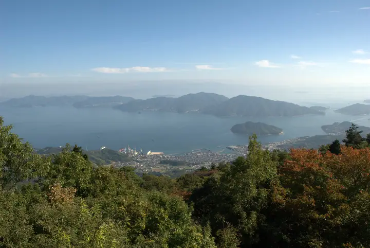
Mount Zendana is the 839.1-meter western summit of the Norosan plateau, an east–west tableland of about two kilometers in Kure City, Hiroshima Prefecture. The plateau lies within Seto Inland Sea National Park and ranks behind only Mt. Rokkō for height in the park, with summit observatories surveying the multi-island scenery of the Inland Sea and, on clear days, as far as Mt. Ishizuchi on Shikoku. Its rhyolite terrain — uplifted some three million years ago and weathered through the Ice Age — produced striking rock formations such as Ōkasaneiwa and Kokasaneiwa.
สรุป Mount Zendana
- อากาศ: วันที่อากาศคงที่ที่สุดใน 7 วันข้างหน้าคือ จันทร์ 9 พฤศจิกายน: ท้องฟ้าแจ่มใส ลมกระโชกสูงสุด 7 ม./วินาที
อากาศ Mount Zendana (รายชั่วโมง 2 สัปดาห์)
วันนี้พระอาทิตย์ขึ้น 06:30 ตก 17:16
| อังคาร 3/11 | พุธ 4/11 | พฤหัส 5/11 | ศุกร์ 6/11 | เสาร์ 7/11 | อาทิตย์ 8/11 | จันทร์ 9/11 | อังคาร 10/11 | พุธ 11/11 | พฤหัส 12/11 | ศุกร์ 13/11 | เสาร์ 14/11 | อาทิตย์ 15/11 | จันทร์ 16/11 | อังคาร 17/11 | |||||||||||||||||||||||||||||||||||||||||||||||||||||||||||||||||||||
|---|---|---|---|---|---|---|---|---|---|---|---|---|---|---|---|---|---|---|---|---|---|---|---|---|---|---|---|---|---|---|---|---|---|---|---|---|---|---|---|---|---|---|---|---|---|---|---|---|---|---|---|---|---|---|---|---|---|---|---|---|---|---|---|---|---|---|---|---|---|---|---|---|---|---|---|---|---|---|---|---|---|---|---|
| เวลาญี่ปุ่น | 21 | 23 | 1 | 3 | 5 | 7 | 9 | 11 | 13 | 15 | 17 | 19 | 21 | 0 | 3 | 6 | 9 | 12 | 15 | 18 | 21 | 0 | 3 | 6 | 9 | 12 | 15 | 18 | 21 | 0 | 3 | 6 | 9 | 12 | 15 | 18 | 21 | 0 | 3 | 6 | 9 | 12 | 15 | 18 | 21 | 0 | 3 | 6 | 9 | 15 | 21 | 3 | 9 | 15 | 21 | 3 | 9 | 15 | 21 | 3 | 9 | 15 | 21 | 3 | 9 | 15 | 21 | 3 | 9 | 15 | 21 | 3 | 9 | 15 | 21 | 3 | 9 | 15 | 21 | 3 | 9 | 15 | |
 |   |   | | |   |   | | | | | |   | | | | |   |   |   | |   | |  |  | | | | | | | | | | | | | | | | | | | | | | | | | |   | | |   | |   | | | | | | |  | | | | | | | | | |   | | | | | | |  | | | ||
| อุณหภูมิ | °C | 9° | 9° | 9° | 9° | 9° | 9° | 11° | 12° | 13° | 13° | 12° | 10° | 11° | 10° | 10° | 10° | 13° | 14° | 14° | 13° | 13° | 14° | 11° | 11° | 13° | 15° | 14° | 9° | 8° | 7° | 6° | 5° | 7° | 10° | 10° | 7° | 4° | 4° | 3° | 4° | 8° | 10° | 11° | 10° | 8° | 8° | 7° | 7° | 10° | 13° | 7° | 5° | 10° | 11° | 7° | 5° | 6° | 10° | 4° | 3° | 8° | 11° | 7° | 5° | 9° | 12° | 6° | 4° | 8° | 12° | 8° | 8° | 11° | 11° | 11° | 11° | 12° | 15° | 8° | 5° | 6° | 9° |
| ฝนและหิมะ | mm | 0.1 | 0.3 | 0.2 | 3.9 | 5.0 | 2.4 | 2.1 | 0.3 | 0.6 | 0.1 | 3.1 | 14 | 0.7 | |||||||||||||||||||||||||||||||||||||||||||||||||||||||||||||||||||||
| หิมะตก | cm | – | – | ||||||||||||||||||||||||||||||||||||||||||||||||||||||||||||||||||||||||||||||||
| หิมะสะสม | cm | 0 | 0 | 0 | 0 | 0 | 0 | 0 | 0 | 0 | 0 | 0 | 0 | 0 | 0 | 0 | 0 | 0 | 0 | 0 | 0 | 0 | 0 | 0 | 0 | 0 | 0 | 0 | 0 | 0 | 0 | 0 | 0 | 0 | 0 | 0 | 0 | 0 | 0 | 0 | 0 | 0 | 0 | 0 | 0 | 0 | 0 | 0 | 0 | 0 | 0 | 0 | 0 | 0 | 0 | 0 | 0 | 0 | 0 | 0 | 0 | 0 | 0 | 0 | 0 | 0 | 0 | 0 | 0 | 0 | 0 | 0 | 0 | 0 | 0 | 0 | 0 | 0 | 0 | 0 | 0 | 0 | 0 |
| ลม | m/s | 4 | 3 | 3 | 3 | 4 | 4 | 5 | 5 | 5 | 5 | 3 | 3 | 3 | 2 | 2 | 3 | 3 | 3 | 2 | 1 | 2 | 4 | 3 | 3 | 2 | 5 | 5 | 4 | 3 | 4 | 4 | 3 | 4 | 3 | 3 | 3 | 3 | 2 | 3 | 2 | 3 | 3 | 3 | 2 | 2 | 2 | 2 | 2 | 2 | 2 | 3 | 2 | 2 | 5 | 3 | 4 | 1 | 4 | 3 | 1 | 1 | 3 | 4 | 1 | 3 | 3 | 4 | 4 | 4 | 3 | 3 | 3 | 4 | 3 | 1 | 2 | 2 | 4 | 4 | 3 | 4 | 3 |
| ลมกระโชก | m/s | 9 | 8 | 7 | 7 | 7 | 9 | 11 | 11 | 11 | 11 | 9 | 8 | 6 | 8 | 6 | 5 | 7 | 8 | 9 | 7 | 7 | 11 | 10 | 8 | 7 | 10 | 11 | 11 | 10 | 9 | 10 | 10 | 9 | 9 | 8 | 8 | 7 | 6 | 6 | 6 | 7 | 8 | 7 | 6 | 5 | 4 | 5 | 4 | 6 | 7 | 9 | 7 | 6 | 12 | 12 | 10 | 10 | 9 | 9 | 7 | 4 | 8 | 10 | 8 | 7 | 9 | 9 | 9 | 9 | 10 | 7 | 7 | 8 | 9 | 8 | 7 | 6 | 11 | 13 | 8 | 8 | 8 |
| ทิศทางลม | ↓ | ↓ | ↓ | ↓ | ↓ | ↓ | ↓ | ↓ | ↓ | ↓ | ↓ | ↓ | ↓ | ↓ | ↓ | ↓ | ↓ | ↓ | ↓ | ↓ | ↓ | ↓ | ↓ | ↓ | ↓ | ↓ | ↓ | ↓ | ↓ | ↓ | ↓ | ↓ | ↓ | ↓ | ↓ | ↓ | ↓ | ↓ | ↓ | ↓ | ↓ | ↓ | ↓ | ↓ | ↓ | ↓ | ↓ | ↓ | ↓ | ↓ | ↓ | ↓ | ↓ | ↓ | ↓ | ↓ | ↓ | ↓ | ↓ | ↓ | ↓ | ↓ | ↓ | ↓ | ↓ | ↓ | ↓ | ↓ | ↓ | ↓ | ↓ | ↓ | ↓ | ↓ | ↓ | ↓ | ↓ | ↓ | ↓ | ↓ | ↓ | ↓ | |
กระท่อม ที่ตั้งแคมป์ และที่พักใกล้ Mount Zendana
ที่ตั้งแคมป์
- Norogawa Dam Camping Ground
รายชื่อที่มี Mount Zendana
100 ภูเขาที่มีชื่อเสียงของจังหวัดฮิโรชิมะ · ระดับความสูงของภูเขา 1003 แห่งในญี่ปุ่น · ภูเขา 1000 แห่งของญี่ปุ่น
ข้อมูลพื้นฐาน Mount Zendana
- ชื่ออื่น
- 野呂山西の山頂
- ความสูง
- 839 ม.
- ที่ตั้ง
- คูเระ, ฮิโรชิมะ
34.262306, 132.666172 - อุทยานแห่งชาติ
- 瀬戸内海国立公園
- เว็บไซต์
- www.pref.hiroshima.lg.jp
- แผนที่เส้นทางเดินเขา
- www.pref.hiroshima.lg.jp (PDF)
- ข้อมูลการเดินทาง
- www.pref.hiroshima.lg.jp
- วิกิพีเดีย
- ja.wikipedia.org