
Mount Ojika
男鹿岳
นาซูชิโอบาระ, โทจิงิ · ความสูง 1,777 ม.
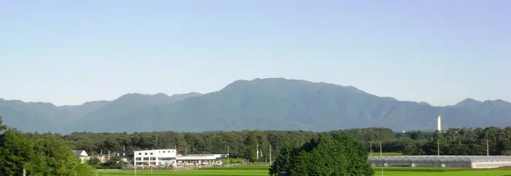
Mount Ojika is a 1,777.1 m peak straddling Minamiaizu Town in Minamiaizu District (Fukushima) and Nasushiobara and Nikkō cities (Tochigi), sitting at the most isolated point of the 70 km prefectural-border ridge that runs from Mount Nasu to Kinunuma-yama. The Tochigi reading is "Ojikadake" while the Fukushima side reads it "Ogadake." It is listed in the Nihon Sanbyaku Meizan, the Tochigi Hyakumeizan, and the Aizu Hyakumeizan, but has no maintained general-use trail. The peak is climbed almost exclusively in residual-snow season (late April through early May), when the dense bamboo grass and bushwhacking are buried under snow. The Ōkawa Pass, the northwest ridge, the Ojika River headwaters, and the abandoned Enna toll road serve as approaches; route-finding and snow-travel competence are required, and the mountain is reckoned among the hardest-to-reach summits in the Sanbyaku Meizan list.
สรุป Mount Ojika
- อากาศ: วันที่อากาศคงที่ที่สุดใน 7 วันข้างหน้าคือ พุธ 4 พฤศจิกายน: ท้องฟ้าแจ่มใส ลมกระโชกสูงสุด 9 ม./วินาที ศุกร์ 6 พ.ย., เสาร์ 7 พ.ย., อาทิตย์ 8 พ.ย. ลมแรง (ลมกระโชกสูงสุด 22 ม./วินาที)
อากาศ Mount Ojika (รายชั่วโมง 2 สัปดาห์)
วันนี้พระอาทิตย์ขึ้น 06:06 ตก 16:43
| อังคาร 3/11 | พุธ 4/11 | พฤหัส 5/11 | ศุกร์ 6/11 | เสาร์ 7/11 | อาทิตย์ 8/11 | จันทร์ 9/11 | อังคาร 10/11 | พุธ 11/11 | พฤหัส 12/11 | ศุกร์ 13/11 | เสาร์ 14/11 | อาทิตย์ 15/11 | จันทร์ 16/11 | อังคาร 17/11 | |||||||||||||||||||||||||||||||||||||||||||||||||||||||||||||||||||||||
|---|---|---|---|---|---|---|---|---|---|---|---|---|---|---|---|---|---|---|---|---|---|---|---|---|---|---|---|---|---|---|---|---|---|---|---|---|---|---|---|---|---|---|---|---|---|---|---|---|---|---|---|---|---|---|---|---|---|---|---|---|---|---|---|---|---|---|---|---|---|---|---|---|---|---|---|---|---|---|---|---|---|---|---|---|---|
| เวลาญี่ปุ่น | 15 | 17 | 19 | 21 | 23 | 1 | 3 | 5 | 7 | 9 | 11 | 13 | 15 | 18 | 21 | 0 | 3 | 6 | 9 | 12 | 15 | 18 | 21 | 0 | 3 | 6 | 9 | 12 | 15 | 18 | 21 | 0 | 3 | 6 | 9 | 12 | 15 | 18 | 21 | 0 | 3 | 6 | 9 | 12 | 15 | 18 | 21 | 0 | 3 | 6 | 9 | 15 | 21 | 3 | 9 | 15 | 21 | 3 | 9 | 15 | 21 | 3 | 9 | 15 | 21 | 3 | 9 | 15 | 21 | 3 | 9 | 15 | 21 | 3 | 9 | 15 | 21 | 3 | 9 | 15 | 21 | 3 | 9 | 15 | |
  |   |  | | | | | |  | | | | |   | |   | | |   | |   | | | |   | | |   |   | | | | | |   |   | |   |   | | | |   | |   | | | | | | | | | | | | | |   | | | | | |  | | | | | | | | | | | | |   | | | | | | | ||
| อุณหภูมิ | °C | 4° | 1° | -1° | -1° | -1° | -1° | -2° | -2° | 0° | 5° | 7° | 8° | 6° | 3° | 3° | 3° | 4° | 5° | 6° | 8° | 9° | 7° | 6° | 5° | 3° | 4° | 8° | 10° | 9° | 5° | 3° | 1° | 0° | -1° | -1° | 0° | -2° | -3° | -3° | -3° | -3° | -3° | -1° | 1° | 0° | -2° | -2° | -2° | -3° | -3° | 0° | 2° | -2° | -3° | 1° | 2° | -3° | -2° | -2° | 0° | -2° | -2° | 1° | 2° | -2° | -2° | -1° | -1° | -4° | -4° | 1° | 4° | -3° | -2° | 5° | 5° | 3° | 5° | 9° | 4° | -2° | -4° | -1° | 2° |
| ฝนและหิมะ | mm | 0.3 | 9 | 10 | 7 | 1.0 | 0.2 | 0.4 | 0.1 | 0.2 | 0.1 | 0.2 | 0.8 | 1.0 | 0.9 | 0.4 | 0.2 | 0.1 | 0.2 | 0.1 | 0.1 | 0.8 | 1.3 | 0.9 | 0.8 | 0.3 | 2.0 | 2.9 | 8 | 1.1 | 2.1 | 0.2 | |||||||||||||||||||||||||||||||||||||||||||||||||||||
| หิมะตก | cm | 0.3 | 0.4 | 0.4 | 0.2 | 0.1 | <.1 | <.1 | <.1 | <.1 | <.1 | <.1 | <.1 | 1.1 | <.1 | <.1 | <.1 | <.1 | |||||||||||||||||||||||||||||||||||||||||||||||||||||||||||||||||||
| หิมะสะสม | cm | 0 | 0 | 0 | 0 | 0 | 0 | 0 | 0 | 0 | 0 | 0 | 0 | 0 | 0 | 0 | 0 | 0 | 0 | 0 | 0 | 0 | 0 | 0 | 0 | 0 | 0 | 0 | 0 | 0 | 0 | 0 | 0 | 0 | 0 | 0 | <1 | <1 | <1 | <1 | <1 | <1 | <1 | <1 | <1 | 0 | 0 | 0 | 0 | 0 | 0 | 0 | 0 | 0 | 0 | 0 | 0 | 0 | 0 | <1 | 0 | 0 | 0 | 0 | 0 | 0 | 0 | 0 | 0 | 0 | 0 | 0 | 0 | 0 | 0 | 0 | 0 | 0 | 0 | 0 | 0 | 0 | 0 | 0 | 0 |
| ลม | m/s | 5 | 3 | 2 | 2 | 2 | 2 | 2 | 2 | 2 | 1 | 1 | 2 | 3 | 3 | 3 | 3 | 1 | 0 | 2 | 1 | 1 | 1 | 1 | 1 | 1 | 2 | 4 | 6 | 5 | 5 | 5 | 6 | 7 | 6 | 5 | 6 | 6 | 6 | 6 | 6 | 6 | 5 | 6 | 7 | 6 | 3 | 2 | 2 | 2 | 2 | 1 | 2 | 2 | 2 | 2 | 4 | 1 | 5 | 6 | 8 | 4 | 4 | 4 | 3 | 1 | 2 | 6 | 8 | 4 | 4 | 2 | 1 | 1 | 0 | 1 | 1 | 0 | 1 | 2 | 5 | 8 | 6 | 3 | 0 |
| ลมกระโชก | m/s | 19 | 16 | 11 | 9 | 8 | 7 | 7 | 7 | 7 | 7 | 5 | 8 | 9 | 9 | 9 | 12 | 10 | 6 | 9 | 7 | 6 | 5 | 5 | 5 | 6 | 10 | 15 | 19 | 20 | 17 | 18 | 19 | 23 | 24 | 21 | 21 | 22 | 23 | 22 | 21 | 21 | 21 | 19 | 20 | 21 | 18 | 11 | 8 | 7 | 8 | 7 | 7 | 8 | 8 | 6 | 11 | 11 | 16 | 25 | 28 | 27 | 15 | 13 | 12 | 10 | 8 | 18 | 24 | 23 | 16 | 14 | 8 | 5 | 5 | 4 | 8 | 6 | 8 | 8 | 19 | 25 | 25 | 18 | 9 |
| ทิศทางลม | ↓ | ↓ | ↓ | ↓ | ↓ | ↓ | ↓ | ↓ | ↓ | ↓ | ↓ | ↓ | ↓ | ↓ | ↓ | ↓ | ↓ | ↓ | ↓ | ↓ | ↓ | ↓ | ↓ | ↓ | ↓ | ↓ | ↓ | ↓ | ↓ | ↓ | ↓ | ↓ | ↓ | ↓ | ↓ | ↓ | ↓ | ↓ | ↓ | ↓ | ↓ | ↓ | ↓ | ↓ | ↓ | ↓ | ↓ | ↓ | ↓ | ↓ | ↓ | ↓ | ↓ | ↓ | ↓ | ↓ | ↓ | ↓ | ↓ | ↓ | ↓ | ↓ | ↓ | ↓ | ↓ | ↓ | ↓ | ↓ | ↓ | ↓ | ↓ | ↓ | ↓ | ↓ | ↓ | ↓ | ↓ | ↓ | ↓ | ↓ | ↓ | ↓ | ↓ | ↓ | |
รายชื่อที่มี Mount Ojika
300 ภูเขาที่มีชื่อเสียงของญี่ปุ่น · 100 ภูเขาที่มีชื่อเสียงของโทจิงิ · 100 ภูเขาที่มีชื่อเสียงของไอซุ · ระดับความสูงของภูเขา 1003 แห่งในญี่ปุ่น · ภูเขา 1000 แห่งของญี่ปุ่น
ข้อมูลพื้นฐาน Mount Ojika
- ชื่ออื่น
- おがだけ
- ความสูง
- 1,777 ม.
- ที่ตั้ง
- นาซูชิโอบาระ, โทจิงิ
37.085310, 139.822075 - วิกิพีเดีย
- ja.wikipedia.org